Home Aviation News NAAE President Highlights Drone Calibration Gaps at IFATSEA ARM

NAAE President Highlights Drone Calibration Gaps at IFATSEA ARM

89
0
drone flight calibration support
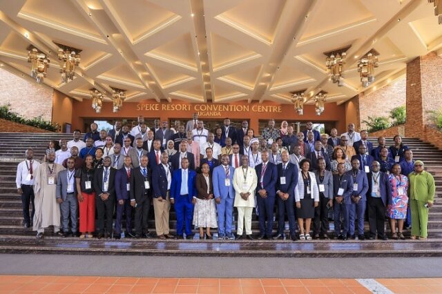
Delegates at the 15th IFATSEA Africa Regional Meeting held in Uganda. Seventh from the left is Engineer Selzin Miri, National President, National Association of Air Traffic Engineers (NAAE), who spoke on drone calibration innovations and limitations.
UBA Tap to Pay

Another challenge raised was drone visibility in controlled airspace. During Nigeria’s trial, Miri revealed, air traffic controllers at the approach unit could not track the drone because it lacked ADS-B or any broadcasting identification.


drone flight calibration support
Caption:
Engineer Selzing Miri, National President, National Association of Air Traffic Engineers (NAAE), stands between two delegates at the 15th IFATSEA Africa Regional Meeting in Uganda. To his right is NAAE’s General Secretary, Engineer Shuaibu Muhammadu. Miri spoke on drone flight calibration support and highlighted regulatory and operational challenges facing its adoption.

BY ANTHONY OMOH


On Day Three of the 15th Africa Regional Meeting of the International Federation of Air Traffic Safety Electronics Associations (IFATSEA), held in Kampala, Uganda from June 17-20, 2025, stakeholders explored evolving technologies shaping air navigation. Discussions focused on artificial intelligence (AI), Remote Virtual Towers (RVT), and drone-assisted calibration of navigational aids.

During one of the technical sessions, National President, National Association of Air Traffic Engineers (NAAE), Engineer Selzing Miri, offered critical insights from Nigeria’s recent drone demonstration. He explained that the trial exposed both advantages and gaps, particularly in regulation and operational safety.

Drone flight calibration support formed a central theme of his remarks, as Miri underlined how new technologies are reshaping conventional procedures.

He praised the collaborative planning involved in the drone trial, describing it as “a fantastic showcase.” According to him, the test revealed how drones can strengthen ground-based maintenance for equipment like Instrument Landing Systems (ILS) and glide slopes.

“In my opinion, the demonstration in Nigeria showed how much time and cost could be saved,” he said. “Traditionally, flight commissioning of an ILS may take around ten hours in the air. With drone support, we can reduce that to six hours or even less, depending on ground preparation.”

He recounted a past situation where 21 flight runs were required to correct a glide slope angle, yet the system still failed the calibration. “The client wanted it passed at all costs. If a drone had been used first, we might have avoided wasting fuel and time on repetitive runs,” he added.

Despite clear advantages, Miri noted that drone flight calibration support still faces major regulatory obstacles. He said existing ICAO procedures demand that flight checks verify signal coverage at distances of 6, 17, and 25 nautical miles. Most drones currently cannot reach those required ranges, limiting their role in formal calibration.

He said, “So while drones are great tools for support, they can’t fully replace flight calibration aircraft yet. The framework doesn’t support it.”

Another challenge raised was drone visibility in controlled airspace. During Nigeria’s trial, Miri revealed, air traffic controllers at the approach unit could not track the drone because it lacked ADS-B or any broadcasting identification.

“At a point, an aircraft was approaching and the controllers couldn’t locate the drone,” he said. “We had to order the pilot to bring it down immediately. That was risky.”

He emphasized the need for drone manufacturers to integrate visibility tools, including radar-identifiable features, to ensure safe co-existence with crewed aircraft. Miri stressed that this oversight needs urgent attention from both manufacturers and civil aviation authorities.

While acknowledging limitations, Miri reiterated his belief in drone technology as a complementary innovation. He argued that drones offer benefits, especially when correcting signal parameters such as glide path angles before live aircraft involvement.

“When you’re adjusting angles, the drone can verify correctness in real time,” he explained. “It saves time because you’re not making on-the-spot corrections while an aircraft is airborne.”

He concluded by urging stakeholders to strengthen technical policies and training. That way, drones could become a mainstream solution in Communication, Navigation, and Surveillance (CNS) and Air Traffic Management (ATM) systems.

“I remain an advocate of new technology,” Miri said. “Until drone operations are fully regulated, they should serve as efficient support tools. But make no mistake—the future of drone-based calibration is very bright.”

The IFATSEA Africa Regional Meeting remains a critical forum for air traffic electronics professionals to share innovations, challenges, and strategies toward safer skies across the continent.

LEAVE A REPLY

Please enter your comment!
Please enter your name here